
Markets Powered by URGNs™
Precision Positioning
URGNs™ enables lane-level certainty across autonomous systems, mobility
platforms, public safety, and infrastructure—especially where GPS fails.
platforms, public safety, and infrastructure—especially where GPS fails.
Level 4/5 Robotaxi OEMs
Highest-priority customers; URGNs™ removes weather/geo-fence restrictions, enabling unsupervised operation nationwide and accelerating scaling to millions of vehicles.

Level 2+/3 ADAS OEMs
Mass-market volume driver; enables year-round hands-off/eyes-off features in snow, fog, tunnels, and poor markings, differentiating premium ADAS packages.
Ride-Hail & Robotaxi Fleets
Highest willingness-to-pay; precise curb approach, faster
dispatching, and all-condition availability directly boost
utilization and revenue per vehicle.


Last-Mile Delivery
Critical for curb/stop accuracy in buried or obscured environments; reduces dwell time, improves package hand-off safety, and enables autonomous delivery expansion.
Microtransit & Shared Mobility Operators
High value from precise routing, dynamic stop management, and passenger safety in dense urban/shared environments; supports on-demand shuttles and micromobility fleets.


Pedestrian & VRU Safety Apps/Platforms
Scales with smartphone users; enables proactive collision avoidance for pedestrians/cyclists via cooperative swarm positioning in crosswalks, school zones, and campuses.
Consumer Navigation Providers
Enhances lane guidance, tunnel/exit accuracy, and reliable ETAs in adverse conditions; premium feature for hundreds of millions of users.

Insurance & Telematics
Fraud-resistant, all-weather lane-keeping and location data enables refined usage-based pricing and risk models, reducing payouts significantly.
Government / DoD / Emergency Services
Fixed fees for resilient PNT access in contested/GNSS-denied scenarios; supports public safety, defense, and infrastructure protection mandates.

Advertising & Location Services
Minor but growing; lane-specific geofencing for targeted ads,
speed warnings, or contextual notifications.
Microtransit & Shared Mobility
High-value for precise, dynamic operations in urban/shared environments. Builds on growing shared mobility trends (projected multi-billion market potential by 2030), with strong early adoption in cities.

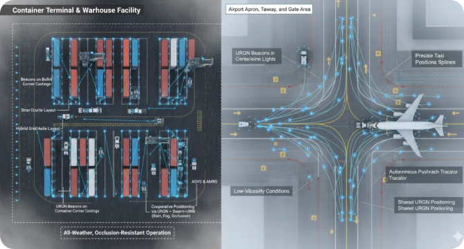
Ports and Airports
Targets vehicle/asset tracking in complex, GNSS-denied environments (market growth to $150B+ globally by 2032 for airport assets). URGN enables reliable, real-time operations for terminal assets, ground support, cargo, and AVs.
VRU Pedestrian/Bike Safety
Scales nationally via smartphone apps for cooperative V2P
alerts/avoidance. Addresses rising VRU safety needs;
revenue from platforms/apps, conservative due to emerging adoption.
Lane-Level Tolling
URGN's precision supports cellular/smartphone-based tolling (feasible and discussed in industry trends), enabling lane-specific charges without gantries. Simpler and less complex than NYC's congestion pricing (which uses E-Pass/infrastructure for $9+ peak tolls, generating revenue but with high setup/political challenges). Potential for nationwide expansion as an alternative.
Level 4/5 Robotaxi OEMs
Highest-priority customers; URGN™ removes weather/geo-fence restrictions, enabling unsupervised operation nationwide and accelerating scaling to millions of vehicles.
Level 2+/3 ADAS OEMs
Mass-market volume driver; enables year-round hands-off/eyes-off features in snow, fog, tunnels, and poor markings, differentiating premium ADAS packages.
Ride-Hail & Robotaxi Fleets
Highest willingness-to-pay; precise curb approach, faster
dispatching, and all-condition availability directly boost
utilization and revenue per vehicle.
Last-Mile Delivery
Critical for curb/stop accuracy in buried or obscured environments; reduces dwell time, improves package hand-off safety, and enables autonomous delivery expansion.
Microtransit & Shared Mobility Operators
High value from precise routing, dynamic stop management, and passenger safety in dense urban/shared environments; supports on-demand shuttles and micromobility fleets.
Pedestrian & VRU Safety Apps/Platforms
Scales with smartphone users; enables proactive collision avoidance for pedestrians/cyclists via cooperative swarm positioning in crosswalks, school zones, and campuses.
Consumer Navigation Providers
Enhances lane guidance, tunnel/exit accuracy, and reliable ETAs in adverse conditions; premium feature for hundreds of millions of users.
Insurance & Telematics
Fraud-resistant, all-weather lane-keeping and location data enables refined usage-based pricing and risk models, reducing payouts significantly.
Government / DoD / Emergency Services
Fixed fees for resilient PNT access in contested/GNSS-denied scenarios; supports public safety, defense, and infrastructure protection mandates.
Advertising & Location Services
Minor but growing; lane-specific geofencing for targeted ads,
speed warnings, or contextual notifications.
Microtransit & Shared Mobility
High-value for precise, dynamic operations in urban/shared environments. Builds on growing shared mobility trends (projected multi-billion market potential by 2030), with strong early adoption in cities.
Ports and Airports
Targets vehicle/asset tracking in complex, GNSS-denied environments (market growth to $150B+ globally by 2032 for airport assets). URGN enables reliable, real-time operations for terminal assets, ground support, cargo, and AVs.
VRU Pedestrian/Bike Safety
Scales nationally via smartphone apps for cooperative V2P
alerts/avoidance. Addresses rising VRU safety needs;
revenue from platforms/apps, conservative due to emerging adoption.

Lane-Level Tolling
URGN's precision supports cellular/smartphone-based tolling (feasible and discussed in industry trends), enabling lane-specific charges without gantries. Simpler and less complex than NYC's congestion pricing (which uses E-Pass/infrastructure for $9+ peak tolls, generating revenue but with high setup/political challenges). Potential for nationwide expansion as an alternative.
About Us
Christ Led. Inspired Innovation. Transformative Tech

"Led by Christ to pioneer God inspired innovation—transformative technologies that save lives and souls by renewing hearts and minds through God-breathed, groundbreaking solutions—while generously stewarding our success to spread the Global Gospel and empower Christ-centered ministries worldwide."
Larry Duke
President/Advisory
Board Member
Gerald White
Advisory Board Member
Leighton Kyler
Advisory Board Member
Chase DusBois
Acting CFO
Melissa Ramos
President URGNs Brazil
Sabbir Nasir
Investment Advisor
Colton Elliott
Investment Advisor
Meet the Team
Ryan Wright
VP of Strategic
Program Management
Damon Hurlburt
Head of Business Development
Douglas Oliveira
Brazilian Legal Counsel
Angela James
Head of Marketing
Rebecca Isemann
Media Relations
Aaron Hurlburt
Digital Solutions
Bill Totman
CISO/Interim CIO
Larry Duke
President/Advisory
Board Member
Gerald White
Advisory Board Member
Leighton Kyler
Advisory Board Member
Chase DusBois
Advisory Board Member
Melissa Ramos
Head of Brazilian
Operations
Sabbir Nasir
Investment Advisor
Colton Elliott
Investment Advisor
Ryan Wright
Head of Strategic
Program Management
Damon Hurlburt
Head of Business Development
Douglas Oliveira
Brazilian Legal Counsel
Angela James
Head of Marketing
Rebecca Isemann
Media Relations
Aaron Hurlburt
Website/Social Media
Bill Totman
Head of Cybersecurity
Deploy URGNs™ in Your Market
Talk to our team about how URGNs™ enables precision positioning where GPS fails.
FAQs
Answers to common questions about the URGNs™ program, technology,
deployment, and impact.
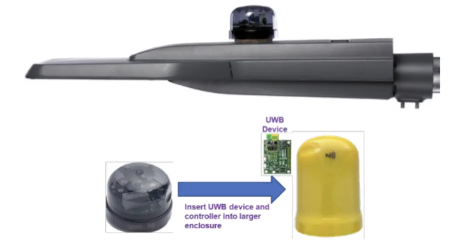
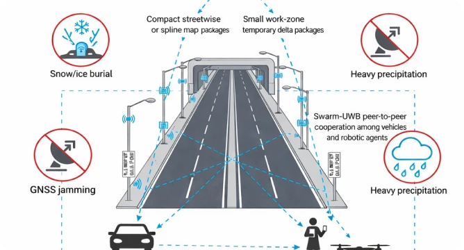
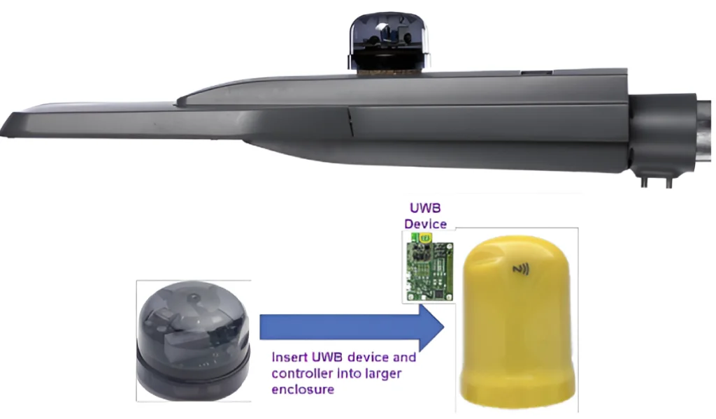
The URGN™ Program deploys UWB tags in existing raised pavement markers and reference posts that maintenance crews already replace annually. This implementation requires no new infrastructure, poles, or additional lane closures—simply a change-order to existing striping contracts. The deployment process integrates seamlessly with scheduled maintenance cycles, minimizing disruption while maximizing coverage.
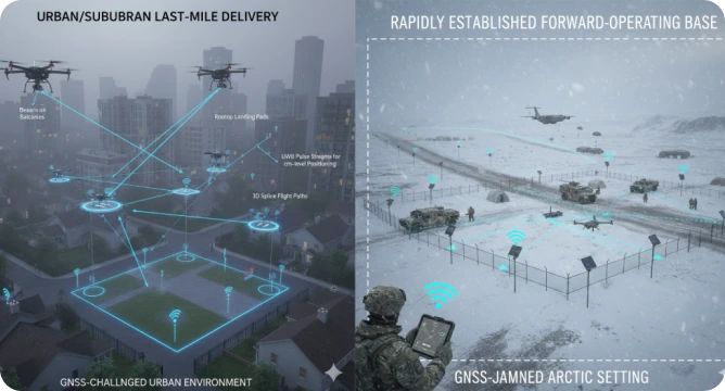
The URGN™ Program prevents thousands of deaths and tens of thousands of serious injuries annually by eliminating 15-40% of winter crashes caused by lane departures in northern states. It provides precise 4-10 cm lane-level positioning in extreme conditions including blizzards, ice, fog, tunnels, and urban canyons where GPS fails. This all-weather capability returns billions of productive hours lost to weather slowdowns while enabling true lane-level congestion management.
Zero. The URGN™ Program operates through a public-private partnership where private industry fully funds deployment and maintains operations for 30 years at no cost to taxpayers. In exchange, the private partner receives the right to provide licensed data access to robotaxi fleets, ADAS manufacturers, insurers, delivery companies, and navigation providers—creating a sustainable business model that requires no public funding.
Yes, the URGN™ Program utilizes standard UWB chips already built into every new iPhone, Android flagship, and 2025+ vehicles. This existing technology provides an unjammable, all-weather positioning system that works when GPS fails. The implementation cost is less than 1/10th of normal restriping costs, with 5x redundancy built in to ensure reliability and continuous operation even during adverse conditions.
The first 500-mile pilot deployment is scheduled for winter 2027, with the first change-orders planned for 2026. This timeline allows for comprehensive testing under real-world winter conditions to validate performance. Upon successful demonstration, the program can rapidly scale nationwide, permanently ending winter lane-departure crashes, enabling Level 4/5 autonomy, and providing resilient positioning when GPS fails for DoD and emergency services.